
Location, Area and Administration of Kota:
Kota district lies between 24º 25′ and 25º 51′ North Latitude and 75º 37′ and 77º 26′ East Longitude. It is bounded on north and north west by Sawai Madhopur, Tonk and Bundi districts. The Chambal river separates these from Kota district and forms the natural boundary. The district is bounded by Jhalawar, and Mandsor district of M.P. on the south, Baran district on the east and Chittorgarh district of Rajasthan on the west.
Kota district has an area of 5098 sq. km. and comprises of 6 tehsils namely Pipalda, Digod, Kanwas, Ladpura (Kota), Sangod & Ramganj Mandi.

Tehsil of Kanwas not shown in map
History of Kota:
- Kota seceded from Bundi in 1631.
- Between 1707- 1713 it was again reunited with Bundi
- Kota became British protectorate in 1817.
- Kota rulers bore the title “Maharao”.
Rulers of Kota:
- Madho Singh
- 2nd Son of raja rattan Singh of Bundi, who confirmed grant of Kota to Madho Singh & separation, took place.
- Mukund Singh
- Jagat Singh
- Kishore Singh
- Ram Singh I (1696-1707)
- United with Bundi (1707-13)
- Bhim Singh I (1713-20)
- Arjun Singh (1720-23)
- Durjan Sal (1723-56)
- Ajit Singh (b. bf.1756-57)
- Chhatar Sal Singh I (1757-64)
- Guman Singh (1764-71)
- Umaid Singh I (1771-1819)
- Dewan Zalim Singh – formed state of Jhalawar – 1791
- Kishor Singh II (1819-28)
- Ram Singh II (1828-1866)
- Chhatar Sal Singh II (1866-89)
- Umaid Singh II (1889-1940)
- Maharo Bhim Singh II (1940-1947)
Historical Places of Kota:
Alnia:
The Alnia Dam is one of the must-see attractions of Kota. It is renowned for the beautiful rock paintings that date back to the Upper Paleolithic age. Still in good condition, they adorn the bank of the river, making this place definitely worth a visit.
Jagmandir Palace:
The Jagmandir Palace was built by one of the queens of Kota between 1743 and 1745, and is situated in the middle of the Kishore Sagar Lake. Built in red sandstone, it is a monument of exquisite beauty. The palace is open to tourists who can enjoy boat rides in the Kishore Sagar Lake and the panoramic view of the palace from the lake. The Keshar Bagh, situated near the Jagmandir Palace is well known for its royal cenotaphs.
Garh Palace:
This large complex, also known as the City Palace, is built in a predominantly Rajput style of architecture. The palace is a sprawling complex of suites and apartments built by different rulers of the Rajput dynasty at different times in history.
Maharao Madho Singh Museum
Situated within the walls of the Garh palace, Maharao Madho Singh Museum houses a splendid collection of Rajput miniature paintings of the Kota school.The exquisite sculptures, frescoes and murals present a breathtaking view.
Fairs & Festivals of Kota:
Kota Dussehra Fair: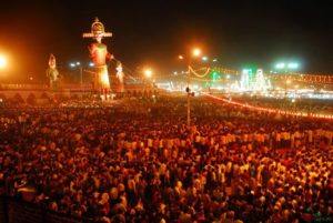
Dussehra marks the victory of Ram over the demon king Ravana, and the rescue of his wife Sita. Dussehra means the Tenth Day, being the 10th day of the bright half of Ashvin. Highlight of the festivities is the theatrical representation of the encounter popularly known as ‘Ramleela’. The climax of the show holds most appeal as it ends with setting alight gigantic effigies of the 10-headed Ravana along with his brother Kumbhkarana and his son Meghnath. These 75-feet tall statues are stuffed with crackers and once set on fire, they burst to create an extravagant show.
Kota Adventure Festival:
Chambal Adventure Festival (9-11 Feb) is three day festival is organized in Kota where Tourists can enjoy Water & Air Sports. Tourists from across the world can witness various events such parasailing, rafting, wind surfing, water skiing and kayaking. Apart from these activities, visitors can also indulge in rock climbing, gliding, trekking, angling and rural excursions.
Gangaur Festival:
(March- April) – This Festival is dedicated to Gauri, the consort of Lord Shiva and the symbol of marital happiness. It is the most important festival of Rajasthan which maidens and married women celebrate with great gusto and enthusiasm. It begins on the day after Holi and is celebrated for eighteen days. Maidens collect poppy flowers from the fields and make garlands for the Goddess.
Annant Chaturdashi Mahotsav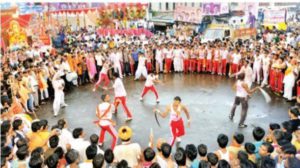
Geography of Kota:
Kota is one of the eastern districts of Rajasthan and is something like a dumber in shape. A major part of the district is a flat plain called Kota-Haravati-Plain which has its average elevation of 250 m. above MSL. The Mukundara-Hill range with flat tops trending NW-SE and rising-up to 492M. above MSL in the South-Eastern and Eastern parts of the district, is the prominent geomorphic feature of the district. The area slopes gently northward from the high table land of Malwa in Madhya Pradesh.
The area is drained by the perennial river Chambal and its north flowing tributaries.
Natural Places of Kota:
Mukundara Tiger Reserve:
The Mukundara Tiger Reserve is 50 kilometers from Kota. Tigers are often relocated here from Ranthambore Reserve. It has a core area of 417 square kilometers and a buffer zone covering 342.82 square kilometers. Other wildlife includes panther, deer, wild boar and bear. This thickly wooded area is home to a large variety of birds as well.
Jawahar Sagar Dam
Built in the yaer of 1972, Jawahar Sagar Dam is part of the chain of dams constructed under the Chambal Valley Project. Erected over the mighty River Chambal, Jawahar Sagar Dam is an important multipurpose dam of the region of Kota that serves several important functions. The dam is situated 26 km downstream from Rana Pratap Sagar Dam.
Garadiya Mahadev Temple:
One can get a grand view of River Chambal from the Garadia Mahadev Temple. Situated on Dabi Road (NH 76), this temple provides an incredible view of the surrounding wilderness. It is a must visit, especially during monsoon.
Natural Resources/Minerals of Kota:
Owing to the total absence of Metamorphic rocks ( to which mostly metallic minerals are associated) no important ore deposits occurr in the district. However, it is compensated by dimensional stone of economic importance, such as limestone and sandstone.
SANDSTONE
Owing to it’s durability, attractive red and white colours and susceptibility to carving and polishing, Vindhyan sandstone has been extensively used as building material.
WHITE SANDSTONE
- Khimuch is an important locality from where white sandstone is produced.
- Since the sandstone is very hard as such it takes polish with great difficulty but if once polished it remains for a very long period.
RED SANDSTONE
- The important quarries are concentrated neer Borawas, Deoli, Kasar, Mandana, Kanwas, villages.
LIMESTONE:
There are extensive deposits of Vindhyan limestone in the district around Morak, Chechat, Deoli, Kotri, Milo, Julmi, Nimoda, Darra etc. The limestone is fine grained, hard and thickly bedded. Being of splittable nature at places, it is extensively quarried in Morak, Suket and Ramganjmandi as slab stone and is famous as “Kota Stone”.
Limestone is also used for lime making near Indargarh, Mandana, etc. Limestone is found in district in following location:
- Morak-Chechat-Deoli Belt:
- Milo-Julmi Belt :
- Deposit near Suket :
- Deposits between Kolipura and Darra :
- Deposit near Nimoda:
- Deposit near Nimoda-Debri:
- Deposit near Gadepan:
Population:
- According to the 2011 census, Kota district has a population of 19,50,491.
- Its population growth rate over the decade 2001-2011 was 24.35%.
- The district has a population density of 374 inhabitants per square kilometer.
- Kota has a sex ratio of 906 females for every 1000 males and literacy rate of 77.48%.