
This chapter deals with space science & technology and important topics with relation to ISRO. We shall now start with basic concepts of space science & technology.
Different Types of Orbits:
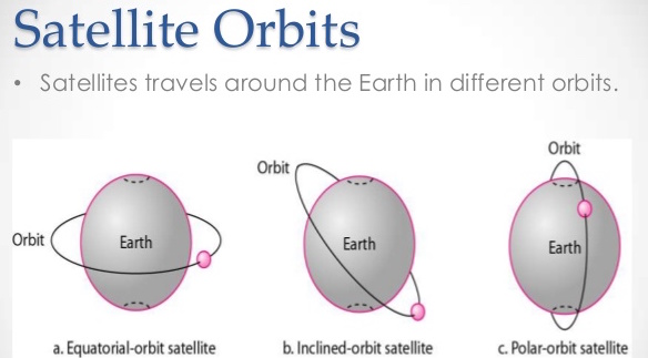
We all know artificial satellites that we send to space revolve around our plant earth. Now, the orbits used by these satellites are defined using equator as reference. Accordingly, we have three types of orbits:
- Equatorial Orbit
- The satellite using this orbit follows equator line on the globe
- Inclined Orbits
- The Satellite using this orbit, revolve at an angle to the equator. However, this angle is less than 90 degrees.
- Polar Orbits
- Satellite using Polar orbits revolves perpendicular to equator and pass above poles (North & South).
More will be clear from Image below.
As you would have observed, the above classification was based on angle the path of revolution of satellites make with equator. Now, there is one more way of classification, which is based on distance from earth’s surface. Classification of satellite orbits based on distance from earth include:
- Low Earth Orbit (LEO):
- Low earth orbit starts at distance of 200Kms from surface of earth and continues till 2000 KMs
- Middle Earth Orbit (MEO):
- Middle earth orbit is situated at distance of 2000 Kms from Surface of earth and continues till 35,786 Kms
- Geo-Synchronous orbits
- This orbit is situated at distance of 35,768 Kms from earth surface.
- Geo-Stationary Orbit
- This orbit is place at distance of 35,786 exact (36,000 in liberal roundup) Kms.
- Satellite Communication
- High Earth Orbits
- Orbits above height of Geo-Stationary Orbits (>36,000 Kms)
Note: Now, in any question, if it is given that satellite is geo-stationary, you should automatically remember than its height will be 3600 Kms
Facts to remember:
1. All geo-stationary orbits are geo-synchronous but all geo-synchronous are not geo-stationary.
- How: First we need to understand what is Geo-Stationary and what is Geo-Synchronous and the difference between the two.
- Geo-Stationary: It is that orbit where speed of satellite revolving earth matches the speed of rotation of earth. So what happens, lets say foo example you(earth) are moving in car at 60Kms/hr and your friend comes on bike(satellite) and you want say some message. How do you do it. Well, often your friend on bike matches his speed with your car and so it feels like both you and he are stationary for a couple of seconds and you can give him the message. This is same thing with earth and geo-stationary satellite. When satellite orbits at 35,786 Km height, its speed matches with rotation speed of earth and it feels like both are stationary and messages can be delivered.

Image Source: Wikipedia - This should also explain to you how when satellite continuously rotates around earth and your cable-TV dish is fixed at just one-angle is able to deliver videos. Because it uses Geo-stationary Satellite to transfer and so from earth it is always stationary. NOTE HERE: TV/ Communication uses Geo-Stationary Satellites.
- Now, coming to Geo-Synchronous orbits, geo-Synchronous orbits are at approximately same height as geo-stationary and so their speed is also same. But coming back to Bike & friend example, your friend not only matched speed but direction of the vehicle as well. If he had only matched speed but not direction then he would go left or right but not parallel. Same happens in Geo-stationary, while the speed is same direction is at some inclination to equator. So it is not stationary but as speed is same, it comes to exactly the same point after 24 hours hence the word “Synchronous”.
- Therefore, since geo-stationary always remains at same place we can say that all geo-stationary are geo-synchronous but not vice-versa.
2. Why ISRO launch Sites are only on East coast of India and not on West coast?
- To explain this we shall again take example of you sitting is a car. Now if you have to throw something, it is always easier to throw in direction of movement of your car but is hard to throw backwards. Why? Because of Physics, the velocity of car is always added to our speed and so when you throw backwards this speed gets subtracted from the speed of stone and so when seen from ground your stone does not go anywhere.
- Now, coming back to ISRO, when it launches satellite it knows that satellite can fail and fall back to earth, in such scenario, it is always better to direct such that satellite falls into sea.
- In West coast: If ISRO tries launching satellite, it has to launch the satellite westwards as sea is at west. But as earth rotated from west to east, it becomes same as throwing stone backwards and it will be highly inefficient.
- In east coast: Sea is at east, and earth also moves from west to east so speed gets added and hence it becomes very efficient. Therefore, now we know why ISRO launch sites are only on east coast.
Back to basic concepts:
1. What is frequency?
- Frequency is number of cycles per second and is measured in Hertz.
2. Units:
- Kilo Hertz – 3 Zeros
- Mega Hertz – 6 zeros
- Giga Hertz – 9 Zeros
Facts to remember:
1. NEWS items on Satellite – say – satellite contain so and so band transponders. What are the different bands used by ISRO?
- L – Band – 1 GHz – 2 GHz
- S – Band – 2 GHz – 4 GHz
- C – Band – 4 GHz – 8 GHz
- X – Band – 8 GHz – 12 GHz
- Ku – Band – 12 GHz – 18 GHz
- K – Band – 18 GHz – 26.5 GHz
- Ka – Band – 26.5 GHz – 40 GHz
Note 1: Now, wherever you see large dish – that dish works on L/S/C band
Note 2: Your Home DTH-TV Dish/ VSAT works on X/Ku/K/Ka band
2. What is transponder?
- Transponder is a device on satellite that receives signals from earth, amplifies them or changes their frequency and transmits them back to earth.
- In simple terms it is Transmitter + Responder
Back to Basic Concepts:
1. What is GPS?
- GPS Stands for Global-positioning system.
- Also called Navstar
- It provides location and time information in all weather conditions, anywhere on or near the Earth where there is an unobstructed line of sight to four or more GPS satellites
- It belongs to United States
2. How many satellite are there in GPS system:
- Originally 24, however in total 32 Satellites of which 31 are in orbit. One is backup.
3. How many satellites are required to know the location of individual
- Four (4). Explanation is too complicated. Be my guest
4. What are other competing systems launched by different countries to GPS system.
- European Union – Galileo positioning system,
- China’s BeiDou Navigation Satellite System,
- Japanese Quasi-Zenith Satellite System,
- India’s Indian Regional Navigation Satellite System.
ISRO
Different types of Satellites sent by ISRO
- Communication Satellites -13 in Nos.
- INSAT-3A, INSAT-3C, INSAT-4A, INSAT-4B, INSAT-4CR, GSAT-6, GSAT-7, GSAT-8, GSAT-10, GSAT-12, GSAT-14, GSAT-15 and GSAT-16.
- Services include television broadcasting, telecommunications, satellite newsgathering, weather forecasting, disaster warning and Search and Rescue operations and societal applications.
- Earth Observation Satellites – 12 in Nos.
- Resourcesat-2,
- Remote Sensing Satellite
- RISAT-1, RISAT-2:
- Stands for Radar Satellite
- Means – Microwave Remote Sensing Satellite
- Carries Synthetic Aperture Radar (SAR) Payload operating in C-band
- Imaging of the surface features during both day and night under all weather conditions.
- Cartosat-1, Cartosat-2, Cartosat-2A, Cartosat-2B
- Cartographic applications,
- Oceansat-2
- Ocean applications
- SARAL
- Satellite with ARGOS and ALTIKA
- Joint Indo-French initiative
- Oceanographic Studies – ocean circulation and sea surface elevation
- Kalpana-1
- Originally METSAT-1
- Vajpayee ji renamed to Kalpana-1
- India’s 1st dedicated meteorological satellite – collect data regarding layer of clouds, water vapor, and temperature of the atmosphere.
- Megha-Tropiques
- Indo-French joint initiative
- Study studying the water cycle and energy exchanges in the tropics.
- INSAT-3D
- Meteorological, data relay and satellite aided search and rescue satellite.
- Resourcesat-2,
- Scientific Exploration Satellites – 2 in Nos.
- Mars Orbiter Mission (MOM)
- Mission was to design and make a spacecraft with a capability to perform Earth Bound Manoeuvre (EBM), Martian Transfer Trajectory (MTT) and Mars Orbit Insertion (MOI) phases.
- Astrosat
- Astronomical & celestial study through X-ray, Optical & UV rays.
- Mars Orbiter Mission (MOM)
- Navigation Satellites – 7 in Nos.
- IRNSS-1A, 1B, 1C, 1D, 1E, 1F and 1G
- IRNSS – Indian Regional Navigation Satellite System:
- Also called: NavIC – Navigation Indian Constellation
- Use: positioning, navigation and timing
- Total 7 Satellites out of which 3 Satellite in GEO stationary orbit (GEO) and four satellites in Geo Synchronous Orbit (GSO) orbit with inclination of 29° to the equatorial plane.

- Services two types:
- Standard Positioning Service (SPS) – Civil Use
- Restricted Service (RS) – military Use
- Experimental Satellites – None
- Small Satellites – None
- Student Satellites – None
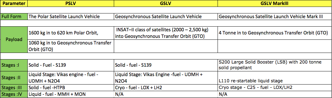
Launch Vehicles:
Launch Vehicles are rockets that carry satellite to desired orbits. At present ISRO have 3 launch vehicles:
- PSLV
- GSLV
- GSLV MARK III
Development of future launch vehicles is also going on, with ISRO working on two Vehicles:
- LMV3
- RLV-TD

Like page so that you don’t miss any important post:
[themencode-fb-page-widget page=”https://www.facebook.com/Rajras-1835370626603310″ width=”250″ height=”50″ hide_cover=”true” show_faces=”false” show_posts=”false”]
You can visit Rajras (Raj ras) – for knowledge/information related to RAS/IAS syllabus, study material & current affairs.

