
Location, Area and Administration of Pali:
Pali district is located between 24°45′ to 26°29′ North Latitudes and 72° 47′ to 74° 18′ East Longitudes . It share its boundaries with 8 district of the state; In South west Sirohi & Jalore, in west Barmer; in south east Rajasamand & Udaipur in north Nagore, in North West Jodhpur and in north east Ajmer shares their boundaries with the district.
The district has total area of 12,387 sq. km, which has been divided into 10 tehsils namely Sojat, Marwar Junction, Jaitaran, Raipur, Sumerpur, Bali, Pali, Rohat, Desuri and Rani.

Tehsil of Rani not shown in map
History of Pali:
Geologists trace the existence of Pali to pre-historic age and maintain that it has emerged from the vast western sea spread over a large part of the present day Rajasthan. In the Vedic age Maharshi Javali stayed in this area for meditation and interpretation of Vedas. The Pandavas in the Mahabharata age also have made this area (near Bali) their resting place during the exile. As a part of ancient Arbuda Province, this area was known as Balla-Desh.
During the Kushana Age, King Kanishka had conquered Rohat and Jaitaran area, parts of today’s Pali district, in 120 AD. Till the end of seventh century A. D. this area was ruled by the Chalukya King Harshavardhana along with other parts of the present state of Rajasthan.
During the period from 10th to 15th century, boundaries of Pali extended to adjoining Mewar, Godwad and Marwar. Nadol was the capital of Chauhans. All Rajput rulers resisted the foreign invaders but individually fought for each other’s land and leadership. After the defeat of Prithviraj Chauhan, against Mohammed Gauri, the Rajput power of the area was disintegrated. Godwad area of Pali become the subjects of then ruler of Mewar, Maharana Kumbha. But Pali city which was ruled by Brahmin rulers with the patronage of neighboring Rajput rulers, remained peaceful and progressive.
The 16th and 17th centuries saw a number of battles in the surrounding areas of Pali. Shershah Suri was defeated by Rajput rulers in the battle of Giri near Jaitaran, Mughal emperor Akbar’s army had constant battles with Maharana Pratap in Godwad area. Again after the Mughals had conquered almost all of Rajputana, Veer Durga Das Rathore of Marwar made organized efforts to redeem the Marwar area from Aurangzeb, the last Mughal emperor. By then Pali had become subservient to Rathores of Marwar state. Pali was rehabilitated by Maharaja Vijay Singh and soon it became an important commercial center.
Under British era in India in 1857, various Thakurs of Pali under the stewardship of Thakur of Auwa fought against the British rule. Auwa fort was surrounded by the British army and then conflicts lasted many days.
Fairs & Festivals of Pali:
Pali District is known for its colorful fairs & festivals, Dusseshra, Diwli, Holi, Ganesh Chaturthi, Janmastmi, Mahavir Jayanti & Mahashivratri etc. are celebrated with sanctity.
SHEETLA SAPTMI FAIR
It is the main fair of the district which is held at Sojat on Chaitra Badi 7 (March-April) Every year. About 20, 00 people assemble in this fair to worship ‘Sheetla Mata’. The people put ‘Pujapa’ and other offerings in the temple in honor of the ‘Mata’. The fairs of ‘Sheetla Mata’ are also held by Bayad in Pali tehsil, Isali in Marwar Jn. tehsil and at Chanod in Bali tehsil.
BARKANA PARASNATH FAIR
The fair is held in Village Barkana of Desuri tehsil on Posh Badi 10 (Dec-Jan) every year. There is a temple dedicated to deity Parasnath. About 10,000 people assemble in the fair to pay their homage to the deity.
SEWARI CATTLE FAIR
This fair is held near village Sewari of Bali tehsil. The duration of the fair is 5 days from posh Badi 2 to 6 (Dec.-Jan.) every year. About 15,000 people assemble in this fair for the purchase and sale of animals Phalna is the nearest railway station for the fair.
LAKKHI MELA- SONANA KHETLAJI
In the beginning of full moon of Chetra month a fair is organized in the basin of local river Sarangawas of Sonana khetlaji temple at Desuri tehsil. This fair represents the folk culture of not only pali district but also of other districts of western Rajasthan. Since this is organized after Holi festival, large number of Gair dancers participate in this fair in their conventional and fancy dresses.
-
Om Banna Temple
The Sacred temple or than of Om Banna is 20 km away from the city on jodhpur-pali highway. The Motor bike of Om Banna is kept there for the devotees for worshiping.
Ranakpur Jain Temple, Pali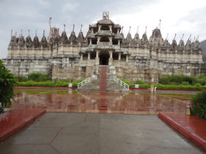
Ranakpur Jain temple is a Jain temple at Ranakpur is dedicated to Tirthankara Rishabhanatha. Dharna Shah, a local Jain businessperson, started construction of the temple in the 15th century following a divine vision. The temple honors Adinath, the first Tirthankar of the present half-cycle (avasarpiṇī) according to Jain cosmology. Rana Kumbha also supported the construction of the temple.
Geography of Pali:
The shape of the district resembles to an irregular triangle and has generally undulated plains with scattered hills. The Aravalli Range runs along the eastern side of the district from south-west to north-east. The highest peak in the district is 1,099 m.
There is no perennial river in the district. The tributaries Lilri, Sukri, Bandi and Jawai, discharge their water into Luni, the principal drainage of western Rajasthan.
There is no lake or natrural spring in the district. But there are number of big and small dams constructed for irrigation purposes. The important dams are Jawai dam in Bali tehsil,Raipur Luni, Hemawas, Kharda and Biratiya Khurd and Walar.
The climate of the district is, on the whole, dry and is very hot in summer and cold in winter. Normal annual rainfall in the district is about 47 cm.
Natural Places of Pali:
-
Jawai dam
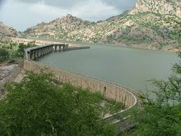
Jawai Dam is one of the biggest dam of western Rajasthan and situated in Sumerpur tehsil of Pali district, having capicity of 6000 million cubic feet. Jawai Dam is a good tourist spot.
Todgarh Raoli Wildlife Sanctuary
Todgarh Raoli Wildlife Sanctuary is spread over Ajmer, Pali and Rajsamand districts of Rajasthan. It occupies about 495 km2 of tropical deciduous forests and grassland. Major wildlife includes leopard, wild boar, chinkara, common langur, sloth bears and Indian wolf. An ancient Lord Shiva temple surrounded by tall trees of Karanj, Tamarind, and Banyan attract tourist from distance place.

Natural Resources/ Minerals of Pali:
Pali district is endowed with wide variety of minerals. Both metallic and non metallic minerals are found. Good quality deposits of asbestos, limestone, gypsum, magnesite, quartz are found which have been exploited for last so many years. The details of mineral deposits are given below.
Copper
- Copper mineral has been reported from Chitar and Naya Kheda.
Lead
- Small occurrences of lead mineralization are located near Punagarh and Sandra area.
Nickel
- Minor indications of nickel are noticed around Ranakpur. The occurrence is not of economic value.
Tungsten
- Numerous scheelite bearing skarns were located near village Kararavav, Kuram, Bhimana, Sirava, Thandiberi etc. in tehsil Bali.
Asbestos
- The asbestos deposits in Pali district are located near Dhal, Mala-ka-Guda, Sendra, Pateria, Chhagri-Ka Bhagal, Goria, Dhambarli, Kanotiya & Ramgarh.
- Small occurrences of asbestos are also noticed near Sandra, Belphana and Halawal villages.
White clay
- At Literia large deposit of white clay was located near the top of the limestone of the Vindhyans and overlain by pebble beds.
Felspar Quartz
- The pegmatites occurring around Beranthia Khurd, Bhanuira, Kalyanpura, Kalakot, Raira in Raipur tehsil near villages Nana in Bali tehsil and Sitapura in Sojat tehsil consist mainly of quartz & felspar.
- The felspar is of pink variety.
Calcite
- Calcite occurrences are located at Bara Guda, Budha Lawa, Kalhab, Kapil-Ki -Bagal, Piplan, Nana, Khemel, Alipur, Khoral, Patan, Oayalpur etc.
- These areas mainly fall in Raipur and Jaitaran tehsil.
Magnesite
- The magnesite deposits of Sarupa-Chhaja, Gafa and Airaberi are located in the thickly forested border areas of Ajmer and Pali districts.
- Small occurrences of magnesite are noticed around Koyalvav, Bhimana, Charia ki Bhagal in Bali tehsil and near Bhira in Raipur tehsil.
Garnet
- This mineral has been exploited in past near Devkhedi and Karanpur villages of Raipur tehsil.
Mica
- This is found associated with quartz, felspar in pegmatits near Kalatiya, Khemal etc. villages.
Soap stone
- Small occurrences of soapstone associated with asbestos in ultrabasic rocks are reported from Kanatia & Manpura in tehsil Raipur.
Read ochre/Red oxide
- It is observed near Botha-ki-Dhani in Raipur tehsil where it was being exploited by private mine owners.
- Red oxide and clay are also found around jaitpura & Shyamgarh and have also been worked in past.
Graphite
- Small occurrences of graphite are located near Bar- Railway station.
Gypsum
- Gypsum has been worked in past near Khutani village.
Wollastonite
- The occurrence of Wollastonite found near Khera Uparla village of Udaipur district which also extends into Pali and Sirohi districts.
Lime stone:
- Limestone is also found in Nana, Kararavav and Thandiberi areas and near Ras, Guria-Dhunimata-DeoliHullan, Thandiberi-Siyava and Mandla-Atbara
Marble
- Deposits are found at at Jadri, Sindru, Diyana, Bankli, Khiwandi, near Sumerpur town in Bali tehsil, Gurah and Kantaliya in Raipur tehsil.
Building Stone:
- Extensively worked Bar conglomerate at Bar, Giri and Lawacha in Raipur tehsil are the only deposits in the district.
Granite:
- Granite occurs in Kharda-Ki-Dhani, Dharm-Dhari-Chotila, Bali-Maniyari, Nadol-Narlai, Kotsamariya, Bar-Sandra- JhakKi-Chowki, Ramniya, Jawariya, Natra-Jhakhora-Rajora areas.
Population:
- According to the 2011 census, Pali district has a population of 20,38,533.
- Its population growth rate over the decade 2001–2011 was 11.99%.
- The district has a population density of 165 inhabitants per square kilometer.
- Pali has sex ratio of 987 females for every 1000 males and a literacy rate of 63.23%.