
Location, Area and Administration of Jhalawar:
The word Jhalawar, literally means “land of the Jhalas” this being the name of the ruling clan of the former state. Jhalawar district lies in the south eastern corner of Rajasthan between 23° 4′ to 24° 52′ North Latitude & 75° 29′ to 76° 56′ East Longitude. It is bounded in the north, north-east and north-west by Kota district and by Madhya Pradesh in the rest of the district.
Jhalawar District has an area of 6219 Sq. Kms which has been divided into 8 tehsils namely Aklera, Asnawar, Gangdhar, Jhalrapatan, Khanpur, Manoharthana, Pachpahar, Pirawa.

Tehsil of Asnawar not on Map
History of Jhalawar
Jhala Zalim Singh , the dewan of Kota, developed Jhalawar (then Chaoni Umedpura ) as cantonment & township, to isolate Kota from Maratha invaders. In 1838, British rulers separated Jhalawar state from Kota state and gave it to Jhala Madan Singh, grandson of Jhala Zalim Singh.
Rulers of Jhalawar:
- Madan Singh (1838–1845)
- 1st independent ruler of Jhalawar.
- Pirthi Singh (1845–1875)
- Bakht or Zalim Singh (1875–1897)
- HH Sh. Bhawani Singh (1897–1929)
- HH Sh. Rajendra Singh (1929–1943)
- HH Sh. Harish Chandra (1943-till merger of Jhalawar State in Rajasthan.)
Historical Places of Jhalawar
Gagron Fort:
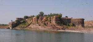 Gagron Fort is an example of ‘Jal Durg’, or Water Fort surrounded by waters of Ahu, Kali and Sindh rivers on three sides. It is included in the list of the UNESCO World Heritage Site. The foundation of this impregnable, magnificent fort was laid in the 7th century. Outside the fort is a Durgah of Sufi Saint Mitheshah, where a fair is held every year during the islamic month of Moharram. Nearby is a monastery of Saint Pipa, a contemporary of Saint Kabir.
Jhalawar Fort:
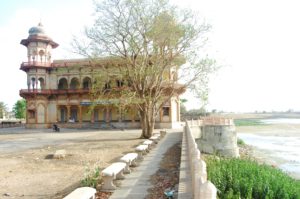
Situated in the centre of the town, the Jhalawar fort or Garh Palace, was built by Maharaj Rana Madan Singh and his successors added beautiful paintings inside the rooms. The Zenana Khas or the ‘Women’s Palace’ has some excellent frescoes on both, walls and mirrors and they are prime examples of the Hadoti school of art.
Bhawani Natyashala:
The Bhawani Natyashala is one of the most unusual theaters in India, constructed in 1921 A.D where Parsi plays and cultural events would take place. This architectural wonder gives one an excellent insight into the world of theatre and art and is known to have an underground passage which allowed horses and chariots to appear on stage.
Jhalarapatan:
 Jhalrapatan, known as the city of bells, is an ancient walled town, founded by Jhala Zalim Singh in 1796 A.D. It is at the same place where the ancient town of Chandrawati was founded by Parmar Raja Chandrasen and later on ravaged by invaders. The entire town lived within the confines of a wall to protect the trade caravans from Pindaris, as Jhalrapatan happened to be one of the junctions of the caravan route. The 10th century Sun Temple (Padma Nabh Temple) is the pride of Jhalrapatan. It is one of the best examples of temple architecture with lovely sculptures. Inside the temple, there is idol of Lord Vishnu.
Fairs & Festivals of Jhalawar
Chandrabhaga Fair
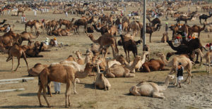 Every year, the Chandrabhaga Fair in Rajasthan attracts travelers, pilgrims and explorers alike with rituals and traditions practiced in this region. Named after the river Chrandrabhaga, it is considered very sacred by the people of Rajasthan.On the full moon night of Kartik purnima devotees take a holy dip in the near by river. A group “Deep Daan” (Offering of lamps) event and cultural programs are of special interest and help tourists acquaint themselves with the people and their culture.
Geography of Jhalawar
The topography of the area is highly undulatory comprising continuous ridges and broad valleys of Vindhyan sandstones and shales, extensive wide plateau, flat topped conical and isolated hills and cultivated plains of Deccan Traps and the alluvial plains.
As a result the district falls in the following physical divisions:
- The Mukandara range which enters the district from the south east, two ridges passing close to Jhalrapatan and continuing north west towards former the boundary of Khanpur with Chhipabarod tehsil of Baran district.
- The hills of Dag, extending upto Pirawa.
- The plateau region with low rounded hills covering most of the southern half of the district.
- The central plain of Pachpahar and Jhalrapatan, extending upto the village of Aklera and Manoharthana across the ridges.
- The plain of Khanpur is between two arms of the Mukandara.
South part of Jhalawar district has the characteristics of the Malwa Plateau, an area of rounded bare hills interspersed by plains. Jhalawar district is an expanse of fertile plain having rich black-cotton soil. The Jhalawar plains stretches in a wide belt from Bhawani Mandi in the west almost up to Asnawar in the east and is bounded on the northern, eastern and southern sides by the Mukandara hills. This is fertile, well watered region crossed by the Ahu and Kalisindh rivers and a number of lesser streams.
Jhalrapatan stands on Vindhyan strats at the northern edge of the great spread of basaltic rocks known as Deccan trap formation, the northern area of which is also called the Malwa trap.
Rivers of Jhalawar:
The rivers and streams of the district belong to the Chambal river system. Except in Gangdhar tehsil, the general flow is from south to north. For the sake of convenience, the rivers of Jhalawar may be divided into two groups — the western group and the eastern group.
- The western rivers are Ahu Piplaj, Kyasri, Kantali, Rawa, Kalisindh and Chandrabhaga. T
- The eastern rivers are Parwan, Andheri, Newaj, Ghar and Ujar. There are artificial lakes Kadila and Mansarovar.
Generally speaking, the Jhalawar rivers have deep beds with the result that water level is below that of the surrounding countryside and hence canals cannot be dug for irrigation.
Natural Resources/ Minerals in Jhalawar:
Due to absence of metamorphic rocks to which most of the metallic minerals are associated, no major metallic mineral of economic importance is found in Jhalawar district. A brief description of minerals found in Jhalawar can be found as under:
Copper:
- There are few old workings of copper just 1 Km. north of Jhalawar town where Malachiteand Azurite are present in Jhalrapatan sandstone of Lower Vindhyans.
Bentonite:
- Bentonite is a variety of clay possessmg inherent bleaching properties.
- It is of great commercial importance specially in chemical industries, oil drilling, decolourising, vegetable oils, rubber industry, foundries etc.
- There are large number of occurrences spread over in Pirawa, Pachpahar and Jhalrapatan tehsils.
- Mathniya-Bhandar Tehsil Pirawa.
- Khetakheda, Tehsil Pirawa.
- Chandi kheri, Teh. Jhalrapatan
- Karodiya-Quadir nagar-Chhoti sunel, Teh.
Limestone:
A. High Grade Limestone:
- There are patches scattered in different parts of the district and have been located near Jhalawar road, Jhinkhriya, Kotri, Kishanpura, Karmakheri, Napaniya etc.
- However few patches are promising which have comparatively less amount of chert and have reasonably good extent. These are near Jhalawar road, Kotri-Gardhankheri, Jhinkhriya and Kotrikhurd.
B. LOW Grade Limestone:
- The low grade limestone belonging to Suket shales of lower Vindhyans and Sirbhu shales of upper Vindhyans is widespread near Gagraun and Sarola kalan respectively.
- The limestone is generally of low grade siliceous, dolomitic and shaly contents.
Laterite:
- Laterite occurs as capping over Deccan trap hills in south western part of Jhalawar district.
- Extensive deposits are found near sarod, Mishroli, Kolvi, Gunavi, Binayaga, Kysara and around Dag, varying in thickness from less than a meter to over 10 mts.
- This rock was excavated locally due to its soft nature to buildt emples and caves during the Buddhist period such constructions arc seen in Kolvi, Binayaga etc
Gypsum:
- Indications of gypsum were seen in Khanpur.
Chert, Agate Chalcedony:
- In Jhalawar district occurrences of agate and associated crypto-crystalline silica products are found spread in many localities.
- They are found scattered in plains as well as in hill slopes.
- Important occurrences are:-
- Near village Nasirabad on Richwa-Bakani road.
- Mundlya Kheri south of Jhalarapatan.
- Diwallkhera, Borband, Donda, Semli Bhawani etc. Thesil Pirwa.
- Mariavada Goverdhanpura, Khokhariya etc, between-Bhawanimandi and Dag.
- Near Garnawad.
Lithomergic Clays:
- The lithomergic clays associated with laterite cappings are found near Sarod, Dag, Gunavi etc. villages but the draw back with these clays is higher iron content which in not separable by washing and electromagnetic separation.
Building Stones:
A. Flaggy Limestone ( Kotahstone )
- Flaggy limestone yielding slabs similar to that of Ramganjmandi has been located in Jhalawar district
- The flaggy limestone of greenish grey colour has been encountered near Kishanpura, Mangal.
B. Flaggy Sandstone:
- Sandstone in the form of slabs and pillars are mined ,on large scale in Jhalawar district.
- There it is associated with two horizons with
- (i) Jhalrapatan sandstone of lower Vindhyans and
- (ii) Lower Bhahder sandstone of upper Vindhyans.
- The important mining areas are: Loharia-ki-Dhani, Manak chauk, Bagdhar, Bakaspura, Asnawar Bhanwrasa, Bhalta, etc. all belonging to Jhalrapatan sandstone. The Bhander sandstone quarries exist near Ambala and Laxmipura.
C. Masonary Stones:
- There are huge deposits of sandstone in the district.
- The non flaggy sandstone is quarried and used as masonary stone at number of places around Jhalawar,Asnawar,Jhalrapatan etc.
Population:
- According to the 2011 census, Jhalawar district has a population of 14,11,327.
- Its population growth rate over the decade 2001-2011 was 19.57%.
- The district has a population density of 227 inhabitants per square kilometer.
- Jhalawar has sex ratio of 945 females for every 1000 males and a literacy rate of 62.13%.